
Walk : Troutbeck Tongue (1,191ft), from Troutbeck
Date : 7th
April 2015
Weather : Fine and Sunny @ 16°C
Distance : 5
miles round trip
Time Taken : 1.5 hours
to summit
Which
part of Lakeland is this walk situated
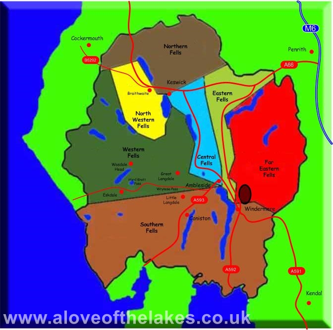
Terrain Overview

Overview
First fell walk
of the year and a little tiddler to start to break
the fell legs in again. A charming little walk which was quite steep in parts
given the overall height of the summit

The walk starts
from the A592 just past
down to the valley floor

After about a
quarter of a mile the public footpath to take is sign posted

The path which
is a tad boggy in places as it gently meanders its way down to the floor of the

Clear blue skies
as we look across the valley to the disused Applethwaite
Quarry

Sue leads the wayb as we approach

Dinner time !!

Continuing down
the path as we approach

The remarkably clear
Trout Beck

The first clear
view of Troutbeck Tongue


Soon after the
bridge an open stile and dismantled electric fence gives way to a faint grass
path that crosses open pasture land

Through the
stile at the intake wall that leads to an old cart track at which point you
take a right turn

The track sweeps
round to the south ridge of the Tongue leading up to Hagg
Gill

Follow the track
up to the first gate where a faint grass path on the left leads on to the start
of the steep climb up the south ridge

Follow the grass
path up to the stile that crosses the fence. Be prepared for some boggy ground

The
start of the steep climb. The path improves as height is gained

Higher up and a
series of foot holes assist the climb towards the rocky spine of the south
ridge

Looking back
down the Troutbeck valley

Higher up to the
stile that leads to the summit approach

The summit cairn
on the left hand side of the shot comes in to view

Sue approaching
the summit

Looking towards
Windermere from the summit cairn

Looking
north towards Caudale Moor on the left. Thornthwaite
Crag on the right with Gray Crag just peeping over Threshtwaite
Mouth

Froswick
from the summit

Looking south
down the

A full view of
the steep ups and downs of Yoke, Ill Bell, Froswick
and Thornthwaite Crag

Looking west
towards Red Screes over the Caudale
Moor ridge
Copyright © aloveofthelakes.co.uk 2010 -
2021